
The Complete Guide to Getting Started with FATMAP
New to FATMAP? Don't worry, we've got you covered with our new video and our step-by-step guide below on getting started!
Downloading the App and Creating Your Profile
1. First things first - download the FATMAP app, available on both iOS and Android
2. Once downloaded, register a new account
You can also do this on the FATMAP website
3. Now make your Profile stand out and add your name, photo, bio and website
Having an up-to-date profile also makes it easier for your friends to find you and for people to see the awesome routes you've published!

Features & Tools
4. Head over to the Map and try searching for some adventures, dropping Waypoints and using the different terrain tools and overlays:
5. Next up, try recording an adventure with our built-in tracking, or connect a tracker and add some of your recent adventures automatically to your profile
How to record your adventures with FATMAP: How can I track my adventures?
Or connect a tracker:

6. View a fly-through of your tracks! Simply select one of your adventures and hit the plane icon to see a glorious fly-through on our high-resolution 3D map
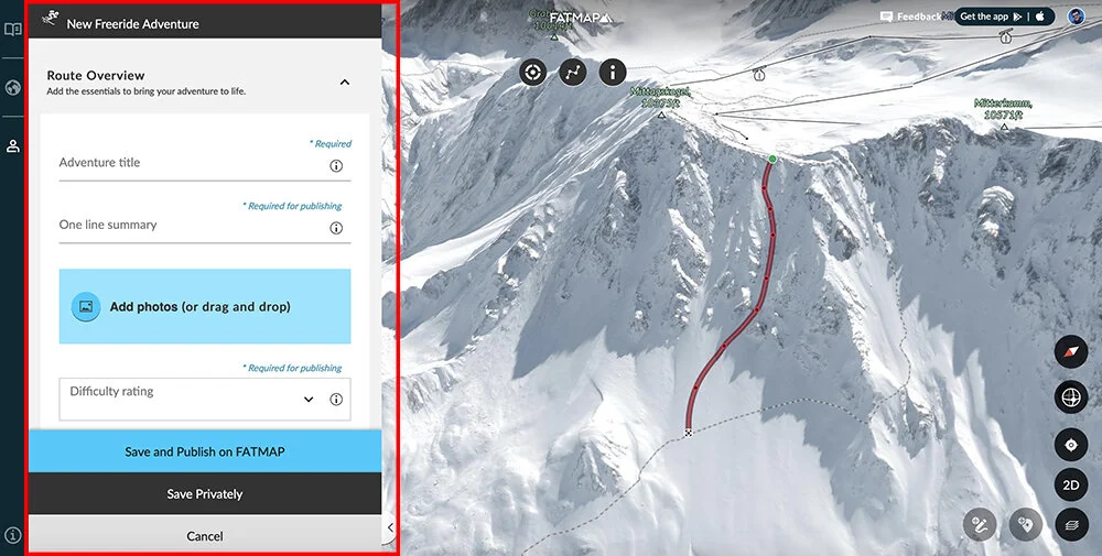
7. Now you've added some activities, take it to the next level and plan a Route
Routes are more than just tracked adventures - they have much more detail, descriptions, photos and information on them - check this one out as an example
You can create Routes on the FATMAP app or website and then publish them publicly to the map for every other FATMAP user to see, or keep them private
8. Share your adventures with the world!
The great thing about adding your routes and adventures to your profile, is you can now easily grab the link to share it. Even better? The link will generate a preview showing your route on the map, along with the stats and activity type!
9. Immerse yourself in the map with 3D view
Feel like seeing the exact view from a specific location on the map? Simply drop a waypoint and tap 3D View!
EXPLORE
10. Download an offline map
Offline maps are a great way to not only save battery when you're out in the mountains, but most importantly it means you'll have access to the map, your routes and your waypoints without needing cell signal
Offline maps are just one feature that come with our Explore membership, you try it for free for 7 days
In need of more inspiration? Check out these videos for even more information on how other people are using FATMAP: