
How to create adventures and import GPX files ⛰
CHECK OUT OUR MORE RECENT BLOG ON USING FATMAP TO CREATE ADVENTURES!
There's no doubt that the key to a successful adventure lies in good planning.
But what does having a good plan mean?
Whether you're planning an ascent of Mont Blanc or a descent of your local bike trail, understanding your route, the type of terrain it runs through and being able to reference it in the mountains can help us stay safe and give us confidence in our adventures.
There are many ways to plan, but we're working on delivering tools to help you create, plan and share your adventures all in one place. Using this guide, you'll be able to plan an adventure anywhere in the world!
Creating adventures (and GPX import)

Where to start
The first step is to choose where you want to go. You can use search to find somewhere specific or browse the destination menu (on the left hand side) for adventures nearby. Once you've settled on a location, it's time to create your adventure.
In the example, we're in Berchtesgaden hiking up the Watzmann (check it out on the map).
There are two ways you can add an adventure, by clicking the Create a new adventure button in your profile or the adventure creation button on the bottom right-hand side of the screen. This will open up a new window where you will be able to select your activity and then you will have the option to:
Draw a route - As shown in the GIF above, begin by clicking on screen where you would like to start your route. You will see you can now move your cursor to create the route and click to place the next point. If you select the SnapTo option on the top of the screen, you will see that the route sticks very easily to existing trails on the map. If you prefer to draw your line freely, deselect the SnapTo option to turn it off. To finish the route, simply hit the Enter/Return key and you will see a finishing flag marking the end.
Upload a track - If you already have the GPX file of your route, you can select this option and upload it straight to FATMAP.
Once you're happy with your adventure, click Save and Continue and it's time to add some information and discover its stats!
It was really easy for me to plan this route as I noticed there was an existing footpath (marked with the dashed lines). FATMAP shows all footpaths and roads as standard as they can help with many planning scenarios.
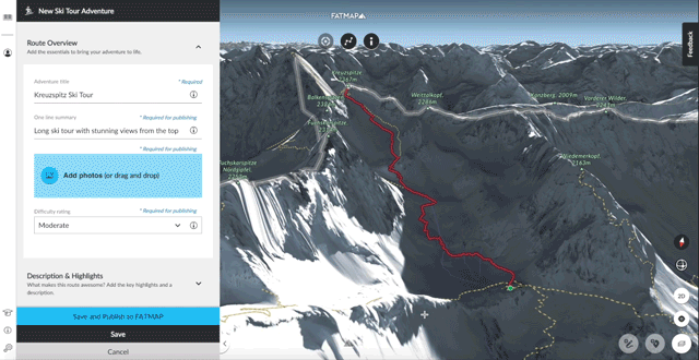
Adding information to your adventures

understanding your adventure
Now your adventure has been added to your profile, you can start adding information. There'll be options to add name, difficulty and a description as well as more activity specific information such as type of trail for mountain biking or exposure for winter sports.
Of course, it's up to you how much detail you add but the better you can describe the route the easier it is to share your plans with others.
When you're done, hit Save and FATMAP will begin calculating the attributes of your adventure. Distance, ascent, descent and max gradient will all be instantly available for every adventure you create.
Choosing Save will keep your adventure private. You can also hit the Save and Publish to FATMAP button to make your adventure public, meaning it is visible to anyone viewing that particular activity on that area of the map.
Making richer adventures
Adding Photos
One of the best ways to really tell the story of your adventures is to add photos. This helps people see what the area looks like, visualise important waypoints you've referenced in the description and also provides a nice preview.
You can give your images titles, add the author and even set the license status. If you hover your cursor over the uploaded images, you’ll see that you can select ‘Make Me Hero’ - clicking that will select that image as the main image for the adventure.
When you have added your images and saved the adventure, clicking on the image will bring up a gallery of all the photos you've added.
Editing your adventures

Add, remove and update points
In the example above, I've decided I want to use a different lift to start the run. This isn't a problem as I can just go back into the editor and add, remove and update points at anytime.
On fatmap.com, go to the My Adventures section of your profile and click on the adventure you would like to edit. Scroll down to the bottom of the info pane of the left and click the Edit button.
Click on any point on the line that you’d like to adjust. With the point selected you can now hit the delete key to remove it, or you can even move it by clicking and dragging it to a new position. You can delete multiple points by clicking on one point, holding the shift key down and clicking on another point, you will see that all the points in between are selected, hit the delete key and all the points will be deleted.
If you want to add any points on a route, hold the A key down and click on the line where you would like to add a new point.
Once you've made all the edits, you can hit save and FATMAP will recalculate the adventures attributes and give you an updated reading.
Adding waypoints and mobile adventures

Now you're happy with your adventure and ready to head out to the mountains, you can view your adventure in your app (along with all your other created adventures) and start adding waypoints.
Waypoints are a great way to add additional information such as the location of a car park or potential turn-around points (waypoints are coming to web very soon!).

If you're a member of FATMAP Explore, then you can access all your adventures and waypoints offline!
Share your adventures with the world...
Once your adventure is over and you're ready to tell you story, you can hit the share button on any adventure on web and on mobile. Either show off your latest summit or inspire others with interesting routes, sharing is the best well to tell your stories with FATMAP. You can even embed FATMAP directly onto your blog or website!
If you have any questions or feedback about creating adventures, then you can always reach us at hello@fatmap.com.